Release Notes - 11th June 2025
New home page
There is now a new Home page tab in your Company view. This has a search bar and quick access to collections such as your recently viewed projects, projects you have created, your recent job & exports, etc. A future update will also allow you to tag projects as Favourites and then quickly access them via a new Favourites tab within the home page.
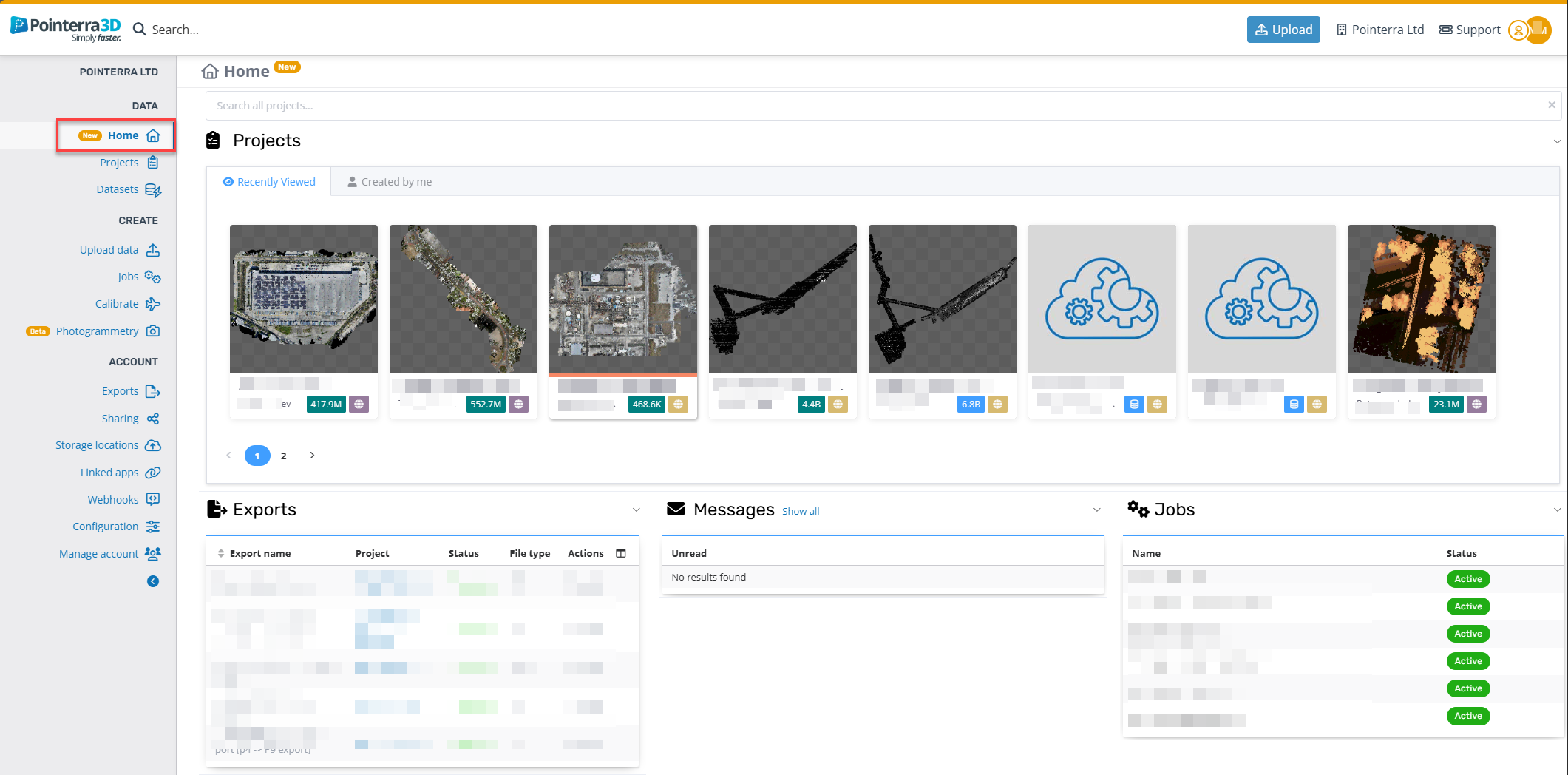
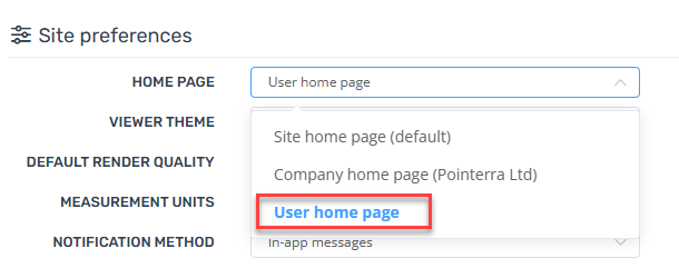
To set the new home page as your default landing page, update your Home Page preference from your user profile (click on your avatar in the top-right of the page and select Profile from the menu). New users will automatically have this set as their default landing page.
Improvements/Changes
Pointerra3D Core
General
Improved scalability and speed of DEM exporting.
Added support for option to have Azure connections route through a fixed IP (allows for whitelisting, etc)
DEM exports now have an option to use a vector layer (with polygons) as a custom tiling scheme.
Improved tiling strategy for 3D CAD/BIM models. This should result in improved render performance in most cases.
Video imports can now extract GPS data from embedded subtitles.
Shared links that have been sent to you will now be listed on your user profile page.
Portal UI
Added column to exports view to show when export was created.
Project and dataset pages now reflect applied filters in the URL. This means you can copy the URL and use it as a bookmark to save favorite filters.
When adding a project into another collection, allow creation of a new collection
Datasets details page now shows srs offset for 3d models if one is specified
When exporting DEM or pointcloud users can now select from the favourite crs list (if set up).
Tiled exports now display the units.
Export operations now show a warning if the exported region does not fit within the target CRS area-of-use.
Viewer
Added context menu to scan markers to allow quick access to functions such as copy scan name/coordinate
-
Scan setup markers now have a right-mouse context menu for:
Ability to hide/unhide scan markers (restricted to users with edit access)
Copy scan name or coordinate to the clipboard
Set min/max height for marker filtering
Enter scanview of scan station (points) view
Scan markers no longer react to click events if another tool is active (stops scan markers from interfering with measurements, cropping, etc)
Changed the scans height filter UI to use a range slider and auto populate the min and max range
Bookmarks and scene defaults now properly store and load the alpha value of orthoimagery datasets
Loading speed of photos in the photo viewer (tiled multi-res photos) significantly improved.
Drawing tool polygons and closed polylines now calculate and (optionally) show the enclosed area. Polylines calculate and display the planimetric (projected onto ground) area.
Drawing tool now has an option to display angles at vertices for polylines and polygons
Made some general improvements to the 2D overlay map UI.
Photogrammetry
Added optional verification stage after GCP selection, which runs the realignment and generates a report before running the full processing.
Added live error estimation for GCPs and added more warnings to prevent misplaced GCPs.
Initial GCP estimation now uses previously clicked points for better alignment.
QC renders of the tie points used to align the project can now be viewed.
Added the ability to specify GCP accuracy.
GCPs are now automatically added as POIs on the finalized project.
Fixed issue where non-dataset admins not being able to complete manual correction.
IIQ photos can now be directly uploaded for photogrammetry.
Photogrammetry reference data can now be loaded from a CSV, TXT, DAT or Metashape XML files.
Analytics
Added edit tool to manually adjust tree peak position
-
Added new QA Assist tool to Poles and Wires editor. Currently runs a check for
Wire count mismatch for spans connected to the same pole
Unfound/unmatched poles from input GIS network data
Pole height vs expected height from GIS network data
Bug Fixes
Ensure that the enabled terrain dataset loads automatically when the viewer is opened.
Fix for some FBX model imports failing when they had unknown properties
Fix for OBJ model corruption when model contains more than 3 vertices per face.
Fix failing model import jobs that use the `offset` option where whitespace was present in the coordinate text.
Fixed "Resume upload" not working for datasets.
Fixed scan images not showing up in point clouds that are merged multiple times.
Fixed photogrammetry jobs failing for certain coordinate systems.