Release Notes - 13th April 2022
New Features
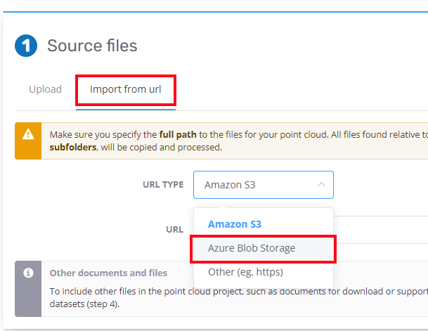
Upload from Azure
Directly reading data from an Azure blob storage container is now supported. The files need to be located in a "folder" within the container and you will need to provide your access key to authenticate. Once the files are read from Azure, the rest of the processing is performed in exactly the same manner as it would if you had uploaded the files using the browser interface. Note that a copy of the original files will be stored in your Pointerra account (in AWS) to support reliable downloading and processing of the data in the future.
Support for other Azure storage options, such as SAS tokens and DFS are planned for future releases.
Support for importing DEM datasets
Gridded elevation data (DEMs) can now be imported as a dataset. In addition to displaying a height-colored representation of the DEM data, there is also an option to process and load the DEM data as a terrain layer replacement within the 3D viewer.
A new option in the DEM exporting workflow has been added, giving you the ability to re-import the exported DEM as a new DEM/terrain dataset in the same project. Using this functionality, you can convert classified ground points from a point cloud into terrain that will allow draping of an orthophoto, for example. This is particularly useful for applications where the ground surface is changing, such as mining and construction.
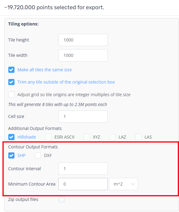
DEM export contour generation option
The DEM export options now include the ability to generate contours as an additional output format. You can specify the contour height interval as well as a minimum area criteria to filter out small contours. Output formats currently supported include SHP and DXF.
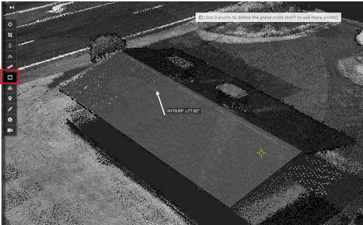
Plane measurement tool
A new measurement tool that fits a plane through a set of selected points has been added. The tool reports the angle (to the horizontal) and bearing of the plane's normal. Future releases will likely add additional capabilities to this tool.
In Beta Release
New features in beta release are not exposed for all customers. Please contact Pointerra support for early access (note availability may depend on your subscription type/level)
Point cloud change detection analytics
A first version of change detection analytics to compare two point clouds has been developed. The current approach implements a full 3D point-to-point comparison - that is, it determines the closest point in the other point cloud and computes the 3D distance as a measure of change. Other metrics (eg. only vertical change) will be available over time. Customers with multi-epoch point clouds that want to trial this functionality should contact sales/support to arrange early access.
Estimate 3D coordinates on 360 photos using correlated point cloud data
In a previous update, the ability to drape POIs and vector drawing layers onto 360 photos was introduced. This relies on the alignment between the photos and the 3D coordinate system being accurate.
The ability to do the reverse, and use well-aligned photos to turn a photo pixel location into a 3D coordinate is now in beta testing mode. This utilises ray casting into the point cloud to find a point (if it exists) that best corresponds to the photo pixel, and hence determine an estimate of the 3D coordinate for a picked point in the photo. The ability to do this allows for features such as POI creation on the images. If the alignment of the 360 photos and the point cloud is accurate enough, then other tasks, such as vector creation and measurement will be possible. This functionality is now available for beta testing and would be most suitable for customers with high quality MLS point cloud data that includes well aligned 360 photos.
Improvements/Changes
Pointerra Core
- When rendering a video that contains 3D models or reality meshes, the viewer now waits for the streaming model data to finish loading before capturing each frame.
- Reality meshes exported from RealityCapture (with zipped geometry data) are now able to be imported as a dataset.
- Dataset file uploads are now fully resumable in the same way as point cloud uploads.
- Processing improvements have significantly reduced the time it takes to run point cloud jobs that involve a large numbers of files.
- Error reporting for failed processing jobs has been improved. More detailed error information is now included in job failure emails.
- A number of new event types have been added to the available webhooks, including: new user invitations, dataset processing status, exports, file downloads, source archive requests.
- Any webhook event can now optionally be routed to a supplied email recipient so that events can be logged to an email address.
- Added an option to combine classification versions across each layer in a merged point cloud. This is located next to the classification version drop down in the 3D viewer
Analytics
- There is now support for viewing the pole light attachments found by the analytics, along with specific tools to edit and create light attachments.
- Edit tools now have an option to change/update the range used for auto-assigning poleIDs.
- Further improvements to the scalability of the Poles and Wires analytics, so that it can now be run on very large (geographic extent) point clouds.
- Further refinements to the ground point classification in areas with steep terrain.
Utility Explorer
- Imagery datasets (from Pointerra3D) can now be added as map layers.
- External web services (WMS, WMTS, TMS) can now be added as map layers.
- Lighting attachments from the poles and wires analytics are now available as a data type in UE.
Bug Fixes
- Converting a vector layer to drawing layer sometimes resulted in incorrect heights due to the vertical datum of the point cloud.
- Dataset uploads could sometimes limit the number of files uploaded to 5000 files.