Displaying base maps and terrain layers
Base maps and terrain layers can be used with georeferenced point clouds to visualise the area surrounding the point cloud as well as make approximate measurements between the point cloud and the surrounding terrain.
Displaying Base Maps and Terrain Layers
Base maps can be enabled or disabled either via the list of datasets on the left hand side or the Global settings menu ("Cog" icon in upper right of the 3D View) under the Map tab (this will only be available for georeferenced point clouds). From here you can show or hide base maps (shortcut key: B), adjust the base map brightness and select the map layer you would like. Alternatively, you can enable and disable the base map layer using the checkbox next to Base map/terrain under the Datasets tab in the Left panel.
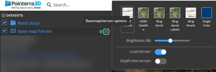
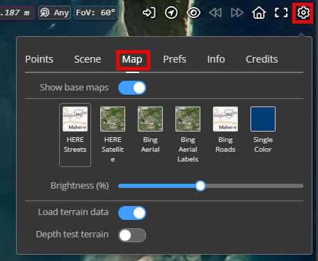
The Load terrain data can be turned off or on independently from the imagery.
The Depth test terrain option can be used for testing against other datasets.
Using your own Imagery
You can add your own imagery layers by uploading orthoimagery (ECW, JP2 or Geotiff) and associating it as a GIS Image dataset with your point cloud project or through an external GIS. It will then appear under the Datasets tab in the Left panel where you can control the visibility in both the 3D viewer and the Overview Map window. Image layers will render on top of other base map layers.
Using your own Terrain
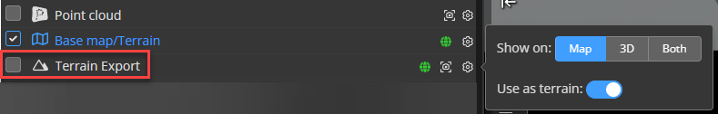
You can add your own terrain layers by uploading an elevation file (32bit elevation TIF). Choose Digital Elevation Model as the dataset and turn on Import as Terrain. It will then appear under the Datasets tab in the Left panel where you can control the visibility in both the 3D viewer and the Overview Map window.
Turning on the Terrain will show a shaded relief map.
To turn on the Use as terrain, either click the globe or use the dataset option.
The base terrain will be overridden by your own terrain.
Your custom terrain will be turned off by default until you Save defaults.