Exporting a DEM/DTM grid
Note: DEM generation is not available for geographic or geocentric coordinate systems.
See help article on how to start the export points procedure.
At the section to choose the file format, select DEM.

I dialogue box will appear below the export file format with options for point filtering. To generate a DEM from pre-classified ground points, choose Export ground only (note that the point cloud must be classified to have this option). Class 2 is considered ground according to the ASPRS standard. Otherwise, the gridding will use all points and generate a DSM. A third option may appear if you have turned on certain classes asking if you want to exclude those points that are turned off.
After choosing the destination CRS, the tiling options, as well as other options, will be available.
Notes:
Tiling is enforced for DEM creation
If you upload a custom tile layout as a vector dataset then you can use that instead.
Each tile is limited to a maximum of 4 million cells
The maximum number of tiles is 10,000
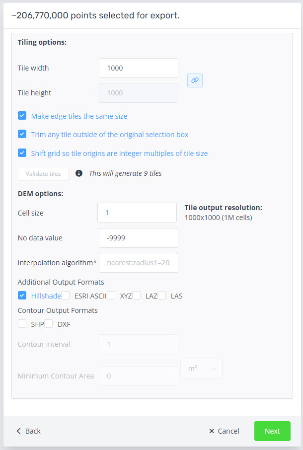
Tiling options
Tile height/width
The size of each tile in the native units of the point cloud. The naming convention will be related to the base coordinates of the tile.
Make edge tiles the same size
This option ensures that the tiles around the edge of the clipping polygon will be generated with the same number of rows and columns as all other tiles.
Trim tiles outside selection
This option will remove any empty tiles not covered by the lidar data.
Shift grid so tile origins are integer multiples of tiles
This option will output tiles will shift the lower left corner of the tile that that of the integer of the tile width and height. For example, if your tile size is 1000m x 1000m, and the grid is currently generating a tile at (345678, 7123456), the tile will be shifted to have its origin at (345000, 7123000). This will likely result in additional tiles being generated to ensure that the entire selected area is included in the output tiles.
Validate tiles
The tiles validation must be run to calculate the final number of tiles.
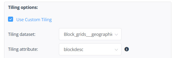
Use Custom Tiling
You can also use a custom tile layout from a vector dataset.
Tiling dataset
Select from dataset attached to the point cloud
Tiling attribute
Select from list of attributes for the tile names.
DEM options
Cell size
This specifies the size of each cell in the output grid (in native point cloud units).
Additional file formats
By default the tiles will be generated in 32 bit elevation geotiff rasters. Additional formats are below:
Hillshade
ESRI ASCII
XYZ
LAZ
LAS
Contour Output Formats
Contours can be export as ESRI Shape file or DXF
The contour interval can be set and uses the vertical units of the point cloud.
Setting the minimum contour area will remove any contour polygons that are smaller than the desired area.
Note: the standard attributes are ID and elevation.